Enhance your fire risk management with local weather data

Wildfires are becoming a growing threat due to climate change, hotter summers, and drier conditions. A small fire can quickly escalate into a catastrophe if the right conditions align—high temperatures, low humidity,strong wind,  and dry vegetation all contribute to fire flammability.

Local fire weather index (FWI) readings across a hilly forest landscape

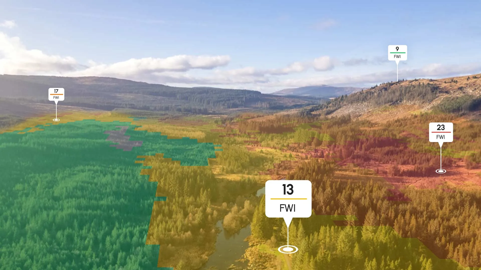
Local weather data for fire risk assessment

Weather conditions such as rain and humidity can vary significantly within just a few kilometers, influencing fire behavior and response strategies. Traditional weather models often fail to capture these microclimatic variations, but Cordulus provides hyper-local data that enhances fire risk assessment.

By integrating ground-truth weather station measurements with AI-driven weather models, Cordulus enhances the precise humidity and rainfall forecasts at a high resolution, enabling decision-makers to act with confidence.

Forest in the morning with dew in the air
Local fire weather index (FWI) readings shown across a varied landscape

Local fire weather index

The Fire Weather Index (FWI) is a widely used metric for assessing wildfire risk, but its accuracy depends on the quality of weather inputs. With Cordulus, fire agencies and land managers can rely on high-resolution data to make informed decisions. This data-backed approach allows for:

Threat Assessment: understand if a situation requires immediate aerial response, on-the-ground firefighting teams, or simple monitoring.
Staffing Plans: allocate resources efficiently based on real-time weather risks.
Public Warnings: provide timely alerts about fire hazards and necessary precautions.
Documentation: provide solid documentation for public warnings and response strategies.

Precise forecasting for fire prevention and response

Accurate forecasting up to 72 hours ahead enables fire agencies to prepare for potential fire outbreaks before they happen. By leveraging AI-driven models combined with real-time weather station data, Cordulus enhances forecast accuracy at the hyper-local level, identifying subtle shifts in humidity, wind patterns, and temperature that can impact fire behavior.

These highly detailed forecasts allow emergency response teams to proactively position resources, adjust suppression tactics, and implement preventative measures before conditions deteriorate. By relying on localized weather models, emergency services can determine the safest strategies for fire suppression, protecting both communities and natural ecosystems.

Firefighter ready to manage wildfires
Firefighting helicopter dropping water on a wild forest fire

Adapting to climate change with localized fire risk management

As climate change leads to more extreme weather conditions, the need for precise, local weather data is more critical than ever. With increasing public use of nature areas and prolonged dry seasons, the demand for proactive wildfire risk assessment continues to grow. Cordulus empowers decision-makers with the local intelligence they need to mitigate fire hazards and protect lives, property, and the environment.

By capturing changes in rain and humidity at the microclimatic level that other services miss, Cordulus helps emergency services stay ahead of wildfire threats. Whether planning firefighting efforts, assessing fire risk for outdoor work, or issuing public safety warnings, accurate local weather data is a vital tool in adapting to a changing climate.